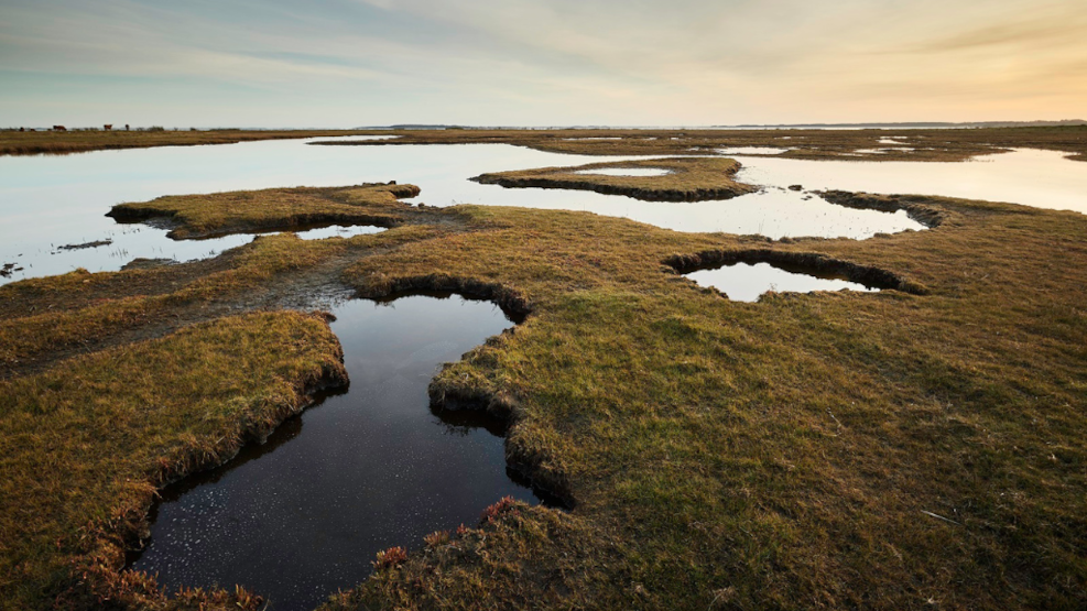
Thurø Østerskov and Thurø Rev
Here you'll find a lovely mix of grazing horses and bathers amidst an interesting natural landscape.
Visit Thurø Østerskov and Reef
Once you've crossed over to Thurø and reached the southernmost point of the island, you'll have arrived at Østerskoven and the reef. It's not possible to drive all the way to the reef or into the forest, but you can park your car at the parking lot at Østerskovvej 14 and walk along paths through Østerskov to the water.
What to experience at Thurø Østerskov and Reef
The forest is protected, but it's a beautiful experience to walk through the trail systems all the way to the reef, where you can walk along the coast to Smørmosen Beach. If you're interested in birds, this is also a good spot for birdwatching.
Geological perspectives at Thurø Østerskov and Reef
Thurø Østerskov extends over a flat or gently undulating moraine plain with no significant differences in height. The surface consists of quite rich moraine clay, causing the groundwater to be high, and the forest floor and path south of the parking lot are often muddy in the winter months and during periods of rainfall.
Towards the coast, the sea's erosion has created an 850 m long and 5.5 m high cliff, showing a cross-section through the upper part of the moraine plain. The layers lie neatly on top of each other and, unlike many other places in the archipelago, have not been folded or otherwise disturbed during the glacial advances of the ice ages.
At the bottom of the cliff, blue-gray moraine clay with scattered stones can be seen. This layer can also be seen at the bottom of the cliff at Smørmosen, 1.3 km further north. It may originate from the younger part of the 'third-to-last ice age', the Elster ice age (480-424,000 years ago), where it was deposited by an ice advance from the Baltic Sea region.
The distinctive landscape, Thurø Reef, is a so-called angular foreland - a marine foreland that forms an approximately triangular shape from the coast. It can arise in several ways, such as here at the 'corner' of Thurø, where coast-parallel currents have brought materials from two different directions - namely from the west along the south coast and from the north along the east coast.
The materials are deposited where the coastal currents meet, and over time, rows of sandy and rocky beach ridges have been built up, one on top of the other. Protected by the beach ridges, the central part of the area has developed into a large beach meadow area consisting of a mosaic of dry grasslands and moist beach meadows with numerous small beach lakes and a network of winding tidal channels (loes). In the summer months, seawater can occasionally be trapped in drainage-free depressions, the surface of which is slowly covered by a white crust of salt as the seawater evaporates. These depressions are therefore called salt pans.
Thurø Østerskov and reef are part of the South Funen Archipelago Geopark
In 2018, Svendborg, Faaborg-Midtfyn, Langeland, and Ærø decided to establish the South Funen Archipelago Geopark with the aim of being designated a UNESCO Global Geopark. The purpose of the geopark is to create and preserve an area that accommodates both people and nature.
A UNESCO Global Geopark should bring the geology, nature, and cultural history of an area into play and convey a message that humans are part of life on Earth. That we are all dependent on the Earth's resources, affected by climate change, and responsible for sustainable development.
The South Funen Archipelago Geopark tells the story of a dramatic rise in sea levels in South Funen and the islands. A sea level rise that shaped a very special nature, which for the last almost 10,000 years has formed the basis for the existence and cultural identity of the area. It's the story of how the landscape and archipelago continue to change and define how we as humans live today. And the South Funen Archipelago Geopark is primarily about understanding how, through sustainable development, we can continue to take care of our special geological, biological, and cultural heritage.